

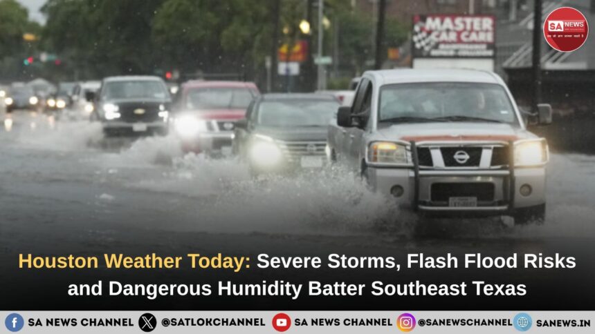
Houston weather is turning increasingly dangerous as repeated thunderstorms, intense lightning, flash flood threats and widespread power outages continue affecting Southeast Texas. Over the past several days, strong storm systems have brought thousands of lightning strikes, damaging wind gusts, heavy rainfall and dangerous road conditions across the Houston metro area, raising fresh concerns just days before the official start of hurricane season. In this article, we explain what is happening across Houston right now, why flood risks are rising, how the storms are disrupting travel and daily life and what residents need to know to stay prepared as more unstable weather develops across the region.
- Highlights on Houston Weather Today
- Houston Storms Bring Lightning, Outages and Travel Disruption
- What Is Houston Weather Like Right Now?
- Why Is Houston Facing Repeated Storms?
- How Severe Are Houston’s Current Storms?
- Why Flash Flooding Remains the Main Concern
- Short-Term Houston Weather Outlook
- Why Is Houston So Humid?
- How Hot Does Houston Get During Summer?
- When Is Hurricane Season in Houston?
- How Can Residents Prepare for Extreme Houston Weather?
- How Is Climate Change Affecting Houston Weather?
- Houston’s Extreme Weather Is a Warning Humanity Can No Longer Ignore
Highlights on Houston Weather Today
- Houston weather this week is being dominated by severe thunderstorms, heavy rainfall and flash flood concerns.
- Meteorologists warned of a high chance of rain and storms across Southeast Texas as Gulf moisture continues feeding unstable weather systems.
- Houston’s flat geography increases flood risks, especially when repeated storms hit already saturated ground.
- Thousands of residents experienced power outages after overnight storms brought lightning and damaging winds.
- Houston summer heat is arriving early, with temperatures nearing 90°F alongside dangerous humidity levels.
- Hurricane season begins in June, raising concerns about worsening flood risks in the coming months.
Houston Storms Bring Lightning, Outages and Travel Disruption
Houston’s latest severe weather outbreak was not just a rain event. Overnight storms produced around 6,000 lightning strikes, knocked out power to thousands of residents and forced emergency crews to respond across several affected areas, including Greenspoint, Rosenberg and South Houston. By late Wednesday morning, CenterPoint had restored service to tens of thousands of customers, though some outages still remained.
The storms also affected travel and continue to. Thunderstorms created delays and ground-stop concerns at both George Bush Intercontinental Airport and William P. Hobby Airport, disrupting daily movement across the region.
What Is Houston Weather Like Right Now?
Houston weather right now is highly unstable, humid, storm-heavy and increasingly flood-prone due to repeated Gulf-fed storm systems moving across Southeast Texas.
Over the past several days, Houston has experienced repeated rounds of thunderstorms, intense lightning, damaging wind gusts and heavy rainfall. Forecasters warned that already saturated ground conditions could increase flash flood risks if additional storm bands continue moving across the same areas.
According to recent weather reports, some parts of Southeast Texas faced a 90% chance of storms as atmospheric moisture surged into the region. Severe weather alerts also warned residents about dangerous road conditions, lightning risks and isolated flooding concerns.
Houston weather is classified as humid subtropical, characterised by hot summers, mild winters and high humidity levels throughout much of the year. However, Houston’s current weather pattern shows how quickly ordinary rain can escalate into a dangerous multi-day weather event.
Why Is Houston Facing Repeated Storms?
Houston is facing repeated storms because warm Gulf moisture is colliding with unstable atmospheric disturbances across Texas.
- Meteorologists explained that moisture-rich air from the Gulf of Mexico is fuelling widespread thunderstorm development across Southeast Texas.
- In addition, repeated storm cells moving over the same regions are increasing the threat of flash flooding.
- Forecasters warned that isolated areas could receive several inches of rainfall within short periods. This becomes especially dangerous in Houston because the city’s flat terrain slows water drainage significantly.
- Houston’s flat geography and intense rainfall patterns increase the city’s risk of flash flooding during severe storms.
- Moreover, Houston’s heavy urban development worsens flooding because concrete surfaces prevent rainwater from naturally soaking into the ground.
How Severe Are Houston’s Current Storms?
Houston’s latest storms are producing dangerous lightning, damaging winds, fallen trees and power outages across multiple areas.
Recent overnight storms reportedly generated thousands of lightning strikes while strong wind gusts damaged trees and disrupted electricity service in parts of Houston and nearby communities. In addition, utility crews worked overnight to restore power after severe weather left thousands of residents without electricity.
Also Read: Area 51: What’s Really Behind America’s Most Mysterious Military Base?
Why Flash Flooding Remains the Main Concern
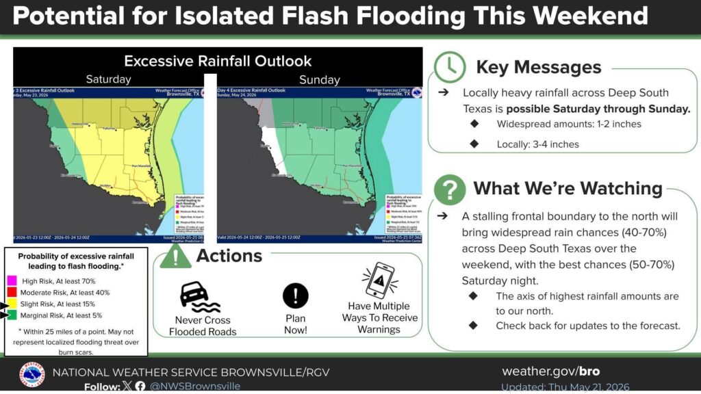
The biggest concern for Houston is not only how much rain falls, but how quickly it falls. Forecasts called for widespread rainfall of 1 to 2 inches, while isolated areas could receive 3 to 4 inches if storms repeatedly move over the same locations. That pattern is especially dangerous in Houston because saturated ground and flat terrain make drainage much slower.
The Weather Prediction Center placed Southeast Texas under a Level 2 of 4 excessive rainfall risk, meaning scattered flash flooding was possible. In Houston, even a short period of intense rain can flood streets, slow commutes and create dangerous driving conditions.
Short-Term Houston Weather Outlook
The current storm system is expected to gradually weaken, but Houston residents should remain alert until rain chances fully drop. Multiple forecasts suggest conditions may become quieter after the heaviest storms pass, with warmer and partly sunny weather returning later in the week. However, temperatures near or above 90°F could return quickly, bringing back the familiar Houston mix of heat and humidity.
This means Houston is moving from a storm-and-flood threat into a heat-and-humidity concern. Residents should continue monitoring weather radar, especially because isolated thunderstorms can still develop even after the main system exits.
Why Is Houston So Humid?
Houston feels extremely humid because, as already stated in this article, warm Gulf air continuously pumps moisture into the atmosphere across Southeast Texas. Even when temperatures remain below 90°F, humidity can make outdoor conditions feel far more oppressive. Temperatures may actually feel much higher than what the scales indicate.
The heat index combines temperature and humidity to describe how hot conditions actually feel to the human body. Humidity also affects daily life across Houston by increasing dehydration risks, raising electricity usage and reducing outdoor comfort.
How Hot Does Houston Get During Summer?
Houston summers regularly exceed 90°F, while humidity can push the heat index far higher.
Meteorologists recently confirmed Houston’s first 90-degree day of 2026 unusually early in the season, signalling that intense summer heat is already arriving across the region.
A similar trend across the world this year as summer heat has been more intense than ever in most parts, including prolonged heatwaves in India.
Houston summer weather is often more physically exhausting than many visitors expect.
Authorities have strongly advised residents to:
- Stay hydrated
- Avoid peak afternoon heat
- Monitor heat advisories
- Keep emergency water supplies available
- Limit prolonged outdoor exposure
When Is Hurricane Season in Houston?
Hurricane season in Houston officially runs from June through November, with peak activity usually occurring between August and September.
Although the official season has not fully intensified yet, Houston’s current rainfall pattern already resembles tropical-style weather conditions because Gulf moisture remains extremely active.
Residents remain highly sensitive to flood risks because Houston has experienced catastrophic storm disasters in recent years. Hurricane season in Houston can transform ordinary rainfall into life-threatening flooding within hours.
Forecasters are encouraging residents to begin storm preparations early before hurricane activity increases later in the summer.
How Can Residents Prepare for Extreme Houston Weather?
Preparing for Houston weather requires flood awareness, emergency planning and constant weather monitoring. Residents should never underestimate Houston storms because conditions can worsen rapidly overnight.
Here are some essential Houston weather safety tips:
- Monitor weather radar frequently.
- Avoid driving through flooded roads.
- Keep flashlights and batteries ready. Charge them if they are rechargeable.
- Charge phones before storms arrive if phones are not working properly.
- Prepare emergency water and food supplies.
- Stay indoors during lightning outbreaks.
‘Turn around, don’t drown’ remains one of the most important flood safety messages in Houston.
Weather experts recommend downloading reliable radar and emergency alert apps because Houston storms can intensify within minutes.
How Is Climate Change Affecting Houston Weather?
Climate change is contributing to more extreme rainfall events, hotter temperatures and increasing weather instability across Houston and the Gulf Coast.
- Scientists warn that warmer Gulf waters can intensify atmospheric moisture and fuel heavier downpours.
- At the same time, expanding urban development is making flood management more difficult across Houston.
- Many experts believe Houston could continue experiencing stronger storms, worsening heat and higher flood risks in the coming years.
But the effects of climate change have been going from bad to worse rapidly in the past years. Can humans deteriorating nature alone cause such upheaval?
Houston’s Extreme Weather Is a Warning Humanity Can No Longer Ignore
Houston weather in 2026 is not merely a reflection of a deteriorating climate, but also of a deteriorating society. Human actions and collective karma influence the world around us far more deeply than most people realise, and this is not blind belief, but a reality increasingly supported by science itself.
As humanity moves closer to chaos on environmental, social and moral frontiers, it becomes imperative to understand the true root cause behind this growing imbalance and how we have ultimately inflicted much of this suffering upon ourselves.
Understand the profound scientific and spiritual explanation of how our actions, thoughts and words shape not only our individual lives, but the very world we inhabit, through this eye-opening spiritual discourse by Jagatguru Tatvdarshi Sant Rampal Ji Maharaj: