Climatology is the branch of atmospheric science focused on studying the Earth’s climate system, atmospheric processes, and long-term weather patterns. Unlike meteorology, which deals with short-term weather forecasts, climatology examines trends and variations over decades or centuries. With the escalating impacts of climate change, understanding climatology has become crucial for disaster prediction, sustainable agriculture, urban planning, and water resource management.
- What Is Climatology?
- Earth’s Atmosphere and Its Circulation
- Atmospheric Circulation
- Lapse Rate, Atmospheric Stability, and Temperature Inversion
- Cloud Formation and Precipitation Types
- Global Wind Patterns and Pressure Belts
- Jet Streams: High-Speed Wind Rivers of the Atmosphere
- Cyclones: Tropical and Temperate Phenomena
- The Indian Monsoon: A Regional Climatic Engine
- Climate Change: A Growing Influence on Climatology
- Climatology’s Role in Addressing Climate Challenges
- Applications of Climatology Across Sectors:
- Conclusion
- FAQs on Climatology
This article explores key concepts including atmospheric circulation, lapse rates, atmospheric stability, cyclones, jet streams, and the Indian monsoon. These fundamentals offer valuable insights into the functioning of Earth’s atmosphere and the reasons behind the climate patterns that shape life on our planet.
What Is Climatology?
Climatology analyzes the Earth’s climate, defined as the average weather over 30 years or more. Climatologists examine temperature, rainfall, winds, humidity, and air pressure to grasp patterns and trends. The science is vital for:
- Understanding global and regional climate patterns
- Predicting natural disasters like cyclones, droughts, and heatwaves
- Examining how climate change affects ecosystems and human activities
- Supporting agriculture, water management, and infrastructure planning
Earth’s Atmosphere and Its Circulation
Understanding Earth’s atmosphere is key to understanding climatology. The atmosphere is a protective layer of gases essential for life, regulating temperature and driving weather and climate systems.
Layers of the Atmosphere
- Troposphere (0–10 km):
The lowest and most active layer holds around 75% of the atmosphere’s mass and most of the water vapor. This is where all weather events like clouds, rain, and storms take place.Temperature decreases with altitude, contributing to weather variability. - Stratosphere (10–50 km):
Home to the ozone layer, which protects Earth from harmful UV radiation. As altitude increases, temperature goes up because ozone absorbs solar energy. To avoid turbulence, commercial planes usually fly in the lower stratosphere. - Mesosphere (50–85 km):
The coldest atmospheric layer, where temperatures drop below -90°C. Meteors burn up in this layer. It remains one of the least explored due to its inaccessibility. - Thermosphere (85–600 km):
Temperatures can exceed 2,000°C from solar radiation, though the thin air makes it feel cold. Auroras occur here as solar particles interact with atmospheric gases.
Atmospheric Circulation
Atmospheric circulation refers to the broad movement of air that transfers heat from the equator to the poles. Driven by solar energy and Earth’s rotation, this circulation forms distinct cells and wind patterns influencing global climates.
Major Atmospheric Cells
- Hadley Cell (0°–30° Latitude):
Warm air ascends at the equator, resulting in low pressure. This air moves poleward at high altitude, descends at about 30°, forming high-pressure zones. The descending air returns to the equator as trade winds, completing the loop. - Ferrel Cell (30°–60° Latitude):
A transitional zone between Hadley and Polar cells. Surface air moves poleward and higher altitude air moves equatorward. This drives the westerly winds in temperate regions. - Polar Cell (60°–90° Latitude):
Cold, dense air sinks at the poles, creating high pressure. Surface winds flow equatorward, meeting warmer air at 60°, creating the polar front—a zone of frequent storms.
Lapse Rate, Atmospheric Stability, and Temperature Inversion
Understanding lapse rates and atmospheric stability is fundamental to explaining weather patterns, cloud formation, and air pollution behavior.
Lapse Rate
Lapse rate refers to how quickly the temperature of the air drops as you go higher in altitude.It’s crucial in determining atmospheric stability and cloud development.
- Environmental Lapse Rate (ELR): On average, 6.5°C per km in the troposphere but varies with conditions.
- Dry Adiabatic Lapse Rate (DALR): 10°C per km for unsaturated (dry) air parcels rising and cooling due to expansion.
- Moist Adiabatic Lapse Rate (MALR): 5–6°C per km for saturated air, slower cooling due to latent heat release during condensation.
Atmospheric Stability
Atmospheric stability affects vertical air movement:
- Stable Atmosphere: The rising air is cooler and denser compared to the air around it, which causes it to sink back.. Results in clear skies and calm weather.
- Unstable Atmosphere: Rising air is warmer and less dense, so it continues rising. This promotes cloud formation, convection, and precipitation—often leading to storms.
Temperature Inversion
A temperature inversion occurs when temperature increases with altitude, trapping cooler air beneath warmer layers. This prevents vertical air mixing.
Causes:
- Clear nights with rapid ground cooling
- Valleys where cold air settles
- Urban areas where heat radiates during the night
Effects:
- Fog formation
- Smog accumulation
- Poor air quality and health impacts
- Suppression of rainfall and cloud formation
Cloud Formation and Precipitation Types
Clouds develop when warm air rises and cools to its dew point, leading to the condensation of water vapor around tiny particles such as dust.
Types of Rainfall
- Convectional Rainfall:
Due to surface heating, common in tropical regions. - Orographic Rainfall:
Humid air pushed upward by mountains cools and turns into liquid. - Frontal Rainfall:
Occurs where warm air masses meet cold ones, causing uplift and condensation along the front.
Global Wind Patterns and Pressure Belts
Atmospheric circulation creates alternating high and low-pressure belts influencing wind and climate globally.
Major Pressure Belts:
- Equatorial Low Pressure (Doldrums) 5°N–5°S:
Intense solar heating causes rising air, heavy rainfall, and thunderstorms. - Subtropical High Pressure (Horse Latitudes) 25°–35°:
Descending dry air leads to deserts and clear skies. - Subpolar Low Pressure (~60° Latitude):
Area where westerly winds meet polar easterlies; often experiences stormy conditions and frontal systems. - Polar High Pressure (90° Latitude):
Cold, dense air descends, creating dry and stable conditions.
Global Wind Systems
Pressure belts drive wind systems shaping weather, climate, and ocean currents.
Trade Winds (30° to Equator):
- From subtropical highs to equatorial lows.
- NE in Northern Hemisphere; SE in Southern Hemisphere.
- Warm, moist winds fueling monsoons and tropical storms.
Westerlies (30°–60°):
- From subtropical highs to subpolar lows.
- Blow west to east in both hemispheres.
- Influence mid-latitude weather, storm systems, and ocean currents.
Polar Easterlies (60°–90°):
- From polar highs to subpolar lows.
- Cold, dry winds from northeast in the north, southeast in the south.
- Contribute to polar climate dynamics.
The Coriolis Effect
Earth’s rotation deflects moving air:
- Northern Hemisphere: Rightward deflection.
- Southern Hemisphere: Leftward deflection.
This shapes:
- Trade Winds: Westward
- Westerlies: Eastward
- Polar Easterlies: Westward
The Coriolis Effect affects ocean currents, cyclones, and jet streams. Without it, winds would flow directly from high to low pressure along meridians.
Jet Streams: High-Speed Wind Rivers of the Atmosphere
Jet streams are narrow bands of exceptionally fast-moving air currents found in the upper levels of the atmosphere, typically in the tropopause, around 9 to 16 kilometers above Earth’s surface. They typically develop at the edges where large air masses with different temperatures meet. These high-altitude air currents play a critical role in shaping weather systems, directing storm paths, and influencing climate patterns across the globe.
Main Types of Jet Streams
- Polar Jet Stream:
The polar jet stream is the most powerful and has the most profound effect on temperate weather systems. It forms at the boundary between cold polar air and warmer mid-latitude air, typically between 50° and 60° latitude in both hemispheres. This jet stream is instrumental in steering mid-latitude cyclones and can shift positions, influencing the severity and frequency of storms in temperate regions. - Subtropical Jet Stream:
Found closer to the equator, between 20° and 30° latitude, the subtropical jet stream plays a crucial role in influencing the onset and retreat of monsoons, particularly the Indian monsoon. It also affects the distribution of precipitation and temperature patterns in the subtropics.
Impacts of Jet Streams
- Aviation: Jet streams directly affect flight routes and fuel efficiency. Pilots often utilize the tailwinds of jet streams to reduce flight times and conserve fuel, while headwinds can significantly increase travel time.
- Weather Systems: Jet streams act as atmospheric highways for cyclones and anticyclones. Their position and strength influence where weather systems develop and how they move.
- Climate Change Influence: With global warming, jet streams are shifting in unpredictable ways. The polar jet, in particular, is weakening due to Arctic amplification, leading to prolonged weather patterns such as heatwaves or cold spells.
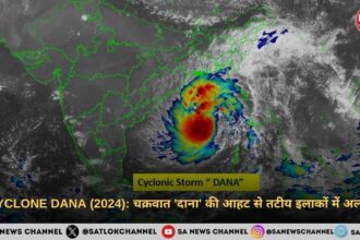
Cyclones: Tropical and Temperate Phenomena
Cyclones are large, spinning systems of low air pressure where winds swirl inwards and upwards. They can be broadly classified into tropical and temperate (or extratropical) cyclones, each with distinct formation mechanisms, structures, and impacts.
Also Read: Climate Collapse: El Niño, Extreme Heat & the Forgotten Spiritual Crisis
Tropical Cyclones
Tropical cyclones are intense storms forming over warm ocean waters near the equator. Known regionally as hurricanes, typhoons, or simply cyclones, these systems are among the most destructive natural phenomena.
Formation Conditions:
- Warm Ocean Waters: Sea surface temperatures above 27°C provide the heat and moisture necessary to fuel these storms.
- Abundant Moisture: Warm, moist air rises and condenses, releasing latent heat that powers the cyclone.
- Coriolis Force: Earth’s rotation imparts the spin necessary for cyclone formation, generally occurring 5° or more from the equator.
- Low Vertical Wind Shear: Uniform wind speeds with altitude allow the storm’s vertical structure to remain coherent.
Structure and Characteristics:
- Eye: A calm, low-pressure center.
- Eye Wall: The zone of strongest winds and heaviest rainfall.
- Spiral Rainbands: Bands of intense storms extending outward.
- High Winds and Heavy Rain: Capable of causing massive destruction through wind damage, flooding, and storm surges.
Lifecycle:
Tropical cyclones typically travel from east to west under trade winds and curve poleward due to the Coriolis effect. They weaken upon landfall, moving over cooler waters, or encountering disruptive wind shear.
Impacts:
Tropical cyclones redistribute heat from the tropics towards the poles and dramatically affect coastal communities through wind damage, flooding, and storm surges.
Temperate Cyclones (Extratropical Cyclones)
Temperate cyclones form in mid-latitudes and are driven by the contrast between warm tropical air and cold polar air, not by warm ocean surfaces. They often form along fronts where these air masses meet, creating areas of low pressure that rotate due to the Coriolis effect.
Characteristics:
- Size: Significantly bigger than tropical cyclones, covering distances of up to 2,500 km.
- Frontal Systems: Characterized by cold, warm, and occluded fronts.
- Weather Variability: Responsible for rain, snow, and storms in temperate zones.
- Duration: Typically last several days and are guided by prevailing westerlies and jet streams.
Impacts:
Temperate cyclones shape the daily weather of much of the Northern Hemisphere, bringing a range of weather conditions, from blizzards to thunderstorms, and are vital in redistributing atmospheric heat.
The Indian Monsoon: A Regional Climatic Engine
The Indian monsoon is a significant driver of weather and agriculture in South Asia, intricately linked to atmospheric circulation, geography, and oceanic conditions.
Southwest Monsoon (June to September):
Triggered by land-sea temperature contrasts and atmospheric pressure gradients, the southwest monsoon brings crucial rainfall to India.
Features:
- Arabian Sea Branch: Brings rain to western India.
- Bay of Bengal Branch: Provides rainfall to eastern and northern India.
- Jet Stream Influence: The Tropical Easterly Jet strengthens while the Subtropical Westerly Jet retreats, aiding monsoon progression.
This monsoon accounts for approximately 75% of India’s annual rainfall and is vital for agriculture, water supply, and hydroelectric power.
Northeast Monsoon (October to December):
Originating from high-pressure systems over cold Asian landmasses, this monsoon brings moisture-laden winds from the Bay of Bengal to southeastern India, particularly benefiting Tamil Nadu.
Factors Influencing the Indian Monsoon:
- ENSO (El Niño–Southern Oscillation): El Niño diminishes, while La Niña boosts the monsoon.
- Indian Ocean Dipole (IOD): A positive IOD enhances, while a negative IOD suppresses rainfall.
- Jet Streams and Tibetan Plateau Heating: These influence pressure patterns crucial for monsoon onset and withdrawal.
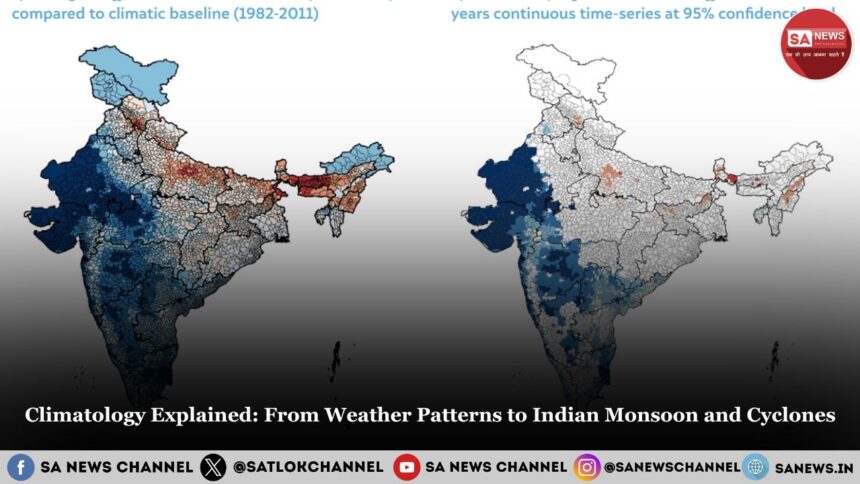
Climate Change: A Growing Influence on Climatology
Climate change, largely driven by human activities, is disrupting established climatic patterns worldwide, influencing jet streams, cyclones, and monsoons.
Observable Effects:
- Rising Temperatures: Increased evaporation and atmospheric instability.
- Melting Glaciers: Threatening water supplies from Himalayan rivers.
- Extreme Weather: Increased frequency and intensity of heatwaves, floods, and storms.
- Monsoon Variability: Unpredictable rainfall patterns with heightened risks of floods and droughts.
- Jet Stream Disruption: Altered positions lead to extreme weather persistence.
- Stronger Cyclones: Warmer seas intensify cyclones in the Indian Ocean.
Human-Induced Drivers:
- Fossil Fuels: CO₂ and methane emissions enhance the greenhouse effect.
- Deforestation: Reduces Earth’s carbon absorption capacity.
- Urbanization: Changes local climates due to the urban heat island effect.
- Pollution: Affects cloud formation and rainfall through aerosols.
Climatology’s Role in Addressing Climate Challenges
Climatology is essential for comprehending, forecasting, and reducing climate-related risks. Through modeling, observation, and analysis, it informs:
- Weather Forecasting: Predicting monsoons and cyclones.
- Resource Management: Guiding water use and agricultural planning.
- Disaster Preparedness: Early warning systems for floods and storms.
- Policy Development: Shaping climate resilience and adaptation strategies.
In India, climatology plays a critical role in managing water resources, forecasting agricultural outputs, and preparing for disasters linked to climate extremes.
Applications of Climatology Across Sectors:
- Agriculture: Planning sowing and harvesting.
- Disaster Management: Flood and cyclone preparedness.
- Aviation: Utilizing jet streams for efficient flight routes.
- Urban Planning: Building climate-resilient cities.
- Public Health: Anticipating climate-driven disease patterns.
Conclusion
Climatology offers a comprehensive framework to understand the complexities of Earth’s atmospheric systems, from high-altitude jet streams to ground-level monsoon rains. In the context of accelerating climate change, this science equips humanity with the knowledge to adapt and mitigate risks, ensuring the sustainability of ecosystems, economies, and societies. As the impacts of climate change become increasingly visible, a robust understanding of climatology is essential not just for policymakers and scientists but for all who depend on Earth’s climatic rhythms for survival and prosperity.
According to Sant Rampal Ji Maharaj, the root cause behind increasing natural disasters, unpredictable weather patterns, and climate change is humanity’s disobedience of the true spiritual path prescribed by the Supreme God Kabir Sahib Ji. He explains that nature operates under divine law, and when people deviate from righteousness, exploit nature, and commit sins, the Earth responds through imbalances like floods, droughts, cyclones, and extreme temperatures.
Sant Rampal Ji Maharaj teaches that only by following true spiritual knowledge, performing Satbhakti (true devotion), and living a moral, simple, and compassionate life, can we bring harmony between nature and humanity. His teachings align with the idea that human actions — both environmental and spiritual — impact the climate. True devotion can reduce karmic burdens, leading to peace in both nature and society.
Thus, Sant Rampal Ji Maharaj’s wisdom offers a holistic solution to climate challenges through spiritual and moral reform.
To know more wisdom by sant rampal ji maharaj visit Sant Rampal Ji Maharaj Youtube Channel
FAQs on Climatology
1. What is Climatology?
Climatology is the study of Earth’s long-term weather patterns and climate systems.
2. How is Climate Different from Weather?
Climate is the long-term average of weather; weather changes daily, climate changes over decades.
3. What Factors Affect Climate?
Climate is affected by latitude, altitude, ocean currents, wind, and human activities.
4. How Do Scientists Study Climate Change?
They use tools like satellite data, ice cores, and climate models to track changes.
5. Why is Climatology Important?
It helps predict climate risks, guide agriculture, and prepare for future environmental challenges.