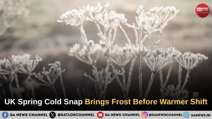
The UK is continuing to experience an unseasonably cold spell as Arctic air pushes across the country, bringing below-average temperatures, frost, showers and even snow over parts of Scotland. Forecasters say the chilly conditions are likely to continue through much of the week due to northerly and northwesterly winds driven by low-pressure systems around the UK and a stormy weather cell over Scandinavia. However, weather models suggest temperatures could gradually recover later in May, with warmer southerly winds potentially lifting temperatures into the high teens or low twenties Celsius in some areas.
- Key Takeaways on UK Spring Weather Forecast
- Arctic Air Keeps UK Colder Than Seasonal Average
- Coldest Week of Spring Brings Frost and Snow Risk
- Pressure Patterns Driving the Cold Weather
- Spring Temperature Swings Continue Across Britain
- Temperatures Could Rise Later in May
- Rain and Showers Still Likely Despite Warmer Outlook
- Outlook for the Rest of May
- Spiritual Reflection During Climate Uncertainty
- FAQs on UK Spring Weather Forecast
Key Takeaways on UK Spring Weather Forecast
- Arctic air is keeping UK temperatures below the mid-May average
- Frost, chilly winds and heavy showers are expected across several regions
- Snow is possible over higher ground in Scotland
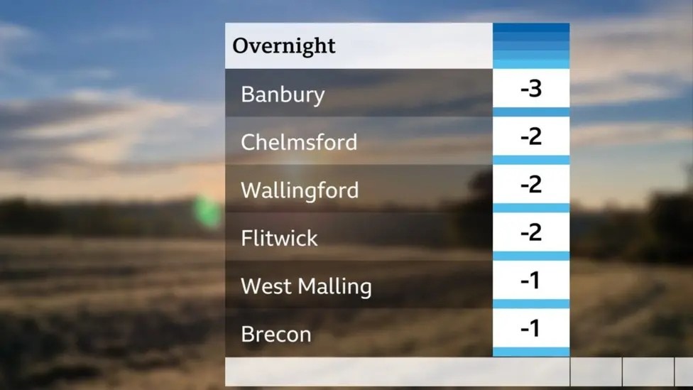
- Temperatures could fall to minus 5 Degree Celcius in some areas during the cold snap
- Low pressure around the UK is drawing in northerly and northwesterly winds
- Temperatures may recover later in May as weather patterns begin to shift
- Southern England and Wales could later see temperatures climbing into the low or mid-twenties Celsius
- Rain and unsettled conditions are still expected in parts of the UK
Arctic Air Keeps UK Colder Than Seasonal Average
After a period of spring warmth earlier in the season, the UK has returned to much colder conditions as Arctic air spreads across the country. Temperatures are remaining several degrees below the seasonal norm, particularly during the middle part of the week.
Northerly winds are currently bringing cold air across the UK, creating daytime temperatures generally between 9 degree celsius and 14 degree celcius in many places. Some areas are also experiencing overnight frosts, with warnings that gardeners could continue to see ground frost during the coming days.
Also Read: Types of Forests and Their Vegetation: A Complete Guide to Global Forest Ecosystems
Tuesday began with frosty conditions across much of England and Wales, while a weak weather front moving across Scotland and Northern Ireland brought light rain instead of frost. Scattered showers later developed across Scotland, Northern Ireland and northern England, although sunny intervals continued between the showers.
Coldest Week of Spring Brings Frost and Snow Risk
Forecasters warned that this could become the coldest week of spring, with Arctic winds expected to push temperatures down to minus 5 degree celsius in some areas.
Low pressure systems surrounding the UK are helping pull colder air southwards from northern Scandinavia and the Arctic Circle. According to weather forecasts, temperatures may remain around 3 degree celsius to 7 degree celsius below average during the cold spell.
The colder conditions are also increasing the possibility of wintry showers in Scotland, particularly over higher ground where snow is possible. Meteorologists noted that such snowfall in the Scottish hills is not unusual for this time of year.
Forecast Conditions Across the UK
| Region | Expected Conditions |
| Scotland | Frost, showers, possible hill snow |
| Northern England | Chilly winds and scattered showers |
| Wales | Frost risk with sunny spells |
| Southern England | Cooler temperatures but drier periods possible |
| Northern Ireland | Light rain followed by showers |
Pressure Patterns Driving the Cold Weather
Meteorologists said the unusual spring chill is being driven by competing pressure systems around the UK.
High pressure, which often supports warmer and more settled spring weather, is currently being held out in the Atlantic. At the same time, low pressure systems to the north and east of the UK are helping maintain northerly and northwesterly winds.
The cold weather pattern has also been linked to a stormy weather cell positioned over Scandinavia, which is sweeping colder air southwards across Britain.
Alex Burkill explained that low pressure around the UK is continuing to pull in colder air from northerly and westerly directions.
According to Mr Burkill: “Weather models go with the idea of cold winds coming towards us, and things are going to stay pretty chilly.”
He also said that there are signs of higher pressure potentially returning later in May, which could help bring warmer and more settled conditions into the early part of June.
Spring Temperature Swings Continue Across Britain
Meteorologists highlighted that large swings in weather patterns are common during spring because it acts as a transition period between winter and summer.
The direction of the wind plays a major role in determining temperatures across the UK. Southerly winds can pull warmer air northwards from the Mediterranean, while northerly winds allow Arctic air to spread south.
Earlier in April, the UK recorded its warmest temperature of the year when Kew Gardens in London reached 26.6 degree celsius. In contrast, Tomintoul in Moray later recorded a temperature of minus 6.8 degree celsius, which was reported as the lowest May temperature since 1997.
Although strong spring sunshine is still expected at times, colder winds are likely to limit daytime warmth through much of the week.
Temperatures Could Rise Later in May
Weather models suggest that conditions may slowly begin to change over the weekend and into next week.
Forecasters expect westerly winds to develop gradually before a possible shift towards southerly winds later in the month. If this pattern develops fully, temperatures could return to the mid-May average of around 12 degree celsius to 18 degree celsius before climbing higher.
Some forecast models suggest parts of southern England and Wales could eventually experience temperatures in the high teens or low twenties Celsius, with the possibility of mid-twenties temperatures in some locations.
Also Read: What Is Happening to Our Planet? Climate Change vs Global Warming Explained
However, meteorologists cautioned that the exact temperatures will depend on:
- The position of high and low pressure systems
- The warmth of incoming air
- The amount of sunshine received
Rain and Showers Still Likely Despite Warmer Outlook
Forecasters warned that warmer temperatures will not necessarily mean completely dry weather across the UK.
As high pressure and low pressure continue competing for dominance, some areas are likely to experience showers or longer periods of rain. Heavy and thundery downpours are also possible in places.
Current forecasts suggest northern and western parts of the UK are more likely to see wetter conditions, while southern and eastern areas may remain relatively drier.
Sunny intervals are still expected at times, and any prolonged sunshine could make temperatures feel noticeably warmer despite the overall cool pattern.
Outlook for the Rest of May
Weather models currently indicate that the cold pattern may gradually weaken later in May as higher pressure begins to rebuild.
Forecasters said conditions could become more settled heading into late May and early June, although changeable weather and periods of rain are still expected before any prolonged warm spell develops across the country.
Spiritual Reflection During Climate Uncertainty
The continuing swings between extreme cold, frost, rainfall and warmer temperatures have once again highlighted how closely human life remains connected to nature and environmental balance. Discussions around climate uncertainty and changing weather patterns are becoming increasingly important across the world.
Followers of Tatvdarshi Sant Rampal Ji Maharaj believe that spiritual awareness, balanced living and moral conduct are essential for restoring harmony between humanity and nature. They also refer to prophecies and spiritual beliefs associated with Saint Rampal Ji Maharaj Ji, according to which His spiritual guidance and true spiritual knowledge can help bring positive change in difficult global conditions, including environmental imbalance.
Supporters of Saint Rampal Ji Maharaj Ji also point to recent relief efforts carried out during flood-affected situations, where pipes, motors and other assistance were reportedly provided to help affected communities.
For more information visit our
Website:www.jagatgururampalji.org
YouTube:Sant Rampal Ji Maharaj
Facebook:Spiritual Leader Saint Rampal Ji
X (Twitter):@SaintRampalJiM
FAQs on UK Spring Weather Forecast
1. Why is the UK experiencing a cold snap in May?
Arctic air, northerly winds and low-pressure systems are pulling colder air across the UK, keeping temperatures below the seasonal average.
2. Could the UK see snow during the spring cold spell?
Yes, snow is possible over higher ground in Scotland during colder showers, according to forecasts.
3. How cold could temperatures get in the UK?
Some areas could see temperatures fall to minus 5 degree celsius during overnight frosts.
4. Will temperatures rise again later in May?
Forecast models suggest temperatures could gradually recover later in May as weather patterns begin to shift.
5. Which parts of the UK may see the warmest weather?
Southern England and Wales could later experience temperatures reaching the high teens or low twenties degree Celsius.